

In Search of the Vanishing River Mole! The mystery of a river balanced on the edge

Few rivers behave quite like the Mole. In some dry summers, it simply vanishes midway along its course, leaving a dry riverbed between stretches of flowing water upstream and downstream. It's one of England's most extraordinary river mysteries.
In August 2026, the Mole vanished again — an event that dominated our summer and raised a host of fascinating questions. Through an almost rainless July, the river had somehow kept flowing before finally disappearing into the chalk beneath the Mole Gap. As we monitored its disappearance and eventual return, the mystery only deepened.
What kept the Mole flowing for so long, and what finally tipped the balance? Where did the swallowed water go, and what feeds the resurgent springs at Thorncroft? And what might this phenomenon mean for wildlife, pollution, groundwater and the future health of the river in a changing climate?
River Mole River Watch, together with friends and partners, has been searching for answers — and our investigations have uncovered some surprising clues.
1. The mysterious disappearing River Mole

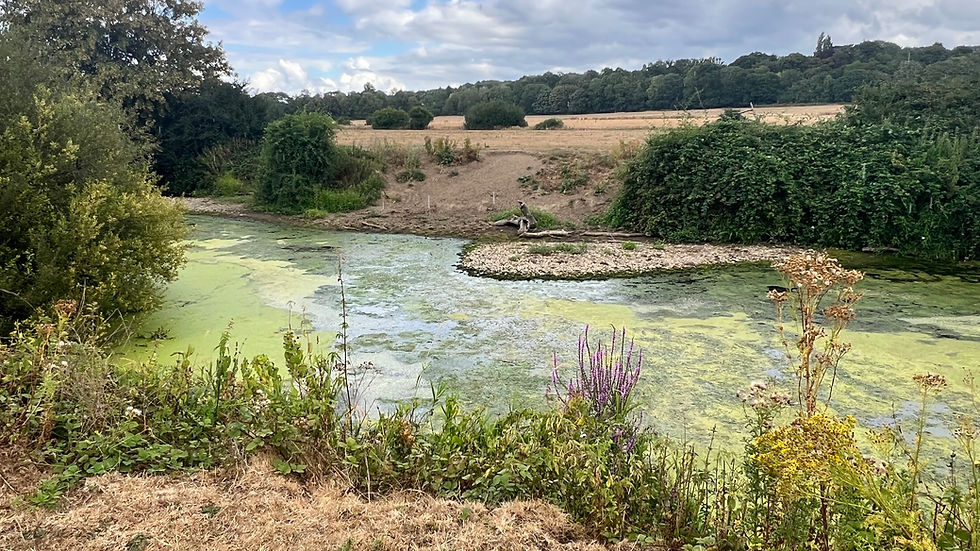
In August 2026, if you stood beside the River Mole through Norbury Park in the Mole Gap, you would have seen almost no river at all. Where water normally flows through the Mole Gap, there were long stretches of dry riverbed, with exposed stones, gravel, silt and isolated pools covered in algae and weed.

Yet farther upstream at the Stepping Stones, people were enjoying the river in the record hot summer, unaware of its disappearance downstream. And beyond the dry reach, at Leatherhead, the Mole was flowing freely again. How could the same river be flowing both upstream and downstream, yet disappear completely in between?
The answer lies beneath our feet. During the summer drought, the Mole's dwindling flow disappeared into swallow holes in the chalk beneath the Mole Gap. Much of that water appears to return through springs farther downstream, particularly around Bluebird Island near Thorncroft.
The big questions we tackle in this post are: what causes the River Mole to vanish through the Mole Gap in some summers but not others? And what happens to the water during its mysterious underground journey?
River Mole River Watch (RMRW) has been investigating these questions, combining our own field observations and those of volunteers and friends along the Mole with decades of rainfall, groundwater and river-flow records. The results reveal some fascinating clues about this extraordinary stretch of river.
2. The Mole mystery stretching back centuries

The Mole's periodic disappearances have fascinated people for centuries. Previous recorded vanishings have occurred in the summers of 1949, 1976 and most recently in 2022 and 2026.

One of the most remarkable investigations was undertaken by geologist C. C. Fagg, who studied the river intensively between 1948 and 1950.
The great drought of 1949 presented Fagg with an unusual opportunity. With help from students and surveyors at nearby Juniper Hall, he mapped active swallow holes and surveyed approximately two miles of exposed riverbed between Ham Bank and the permanent water near Leatherhead.

Fagg's measurements revealed an exceptionally shallow overall gradient, but a remarkably uneven riverbed full of hollows and depressions which we still find today.
The Mole Gap is no ordinary river valley. Between Box Hill and Thorncroft, the river cuts through the chalk of the North Downs, where fissures and swallow holes allow water to disappear underground. In most summers, sufficient water arrives from the Upper Mole for the river to continue flowing downstream. But when incoming flow falls too low, the swallow holes can capture all of it, leaving entire stretches of riverbed dry.
Fagg witnessed this process, including substantial quantities of water reappearing through springs around Thorncroft Island. The phenomenon continued through later droughts, notably 1976 and 2022. In 2025, we think the Mole narrowly avoided another major vanishing, but in summer 2026 it disappeared again.
The historical rainfall records show that these events did not all happen in the same way.
3. Five summers, five different rainfall stories

Our analysis reveals no single rainfall pattern leading to the Mole's disappearance. Vanishings have followed both wet and dry winters and springs. The common factor, perhaps unsurprisingly, appears to be a prolonged shortage of rainfall during summer.
The historic drought of 1976 was the most extreme example. The South East experienced exceptionally dry conditions throughout the preceding seasons: just 77 mm of rain in winter, 54 mm in spring and 56 mm over the entire summer. The 1976 vanishing saw the most extensive dry channel extending from near Burford Bridge to Thorncroft.
The 2026 vanishing tells a very different story. It followed an exceptionally wet winter, with 312 mm of rainfall — four times the winter total of 1976! Even June was wetter than average, receiving 135% of normal rainfall. The vanishings of 1949 and 2022 followed different rainfall patterns again.
So why did the Mole disappear in 2026 but narrowly escape in 2025?
Both years experienced exceptionally dry springs, receiving just 33% and 40% of average spring rainfall respectively. The crucial difference came in July. In 2025, substantial rain returned, with 70 mm recorded at Leatherhead and 104 mm at Charlwood (189% of the July average). But July 2026 was almost completely rainless: our three local gauges recorded just 0.5 mm at Leatherhead and none at Burstow or Pease Pottage.
Daily mean flow at Dorking during July–August in 2022, 2025 and 2026. Despite very low flows and almost no July rainfall, the Mole continued flowing into the Gap throughout July 2026, even though 2022 saw an earlier vanishing.
What’s extraordinary is that the Mole kept flowing through the Gap throughout the whole of July 2026.

The chart above shows river flow at Dorking, where the Mole enters the chalk reach. As expected, 2025 flows were clearly higher. But the striking comparison is with 2022: in July 2026, Dorking flow fell below 2022 levels, even though the river had already vanished by 14 July in 2022. Yet in 2026 the Mole somehow continued flowing on the surface through an almost completely rainless month. That persistence is remarkable for a river draining a largely clay catchment, where flows often respond quickly to rainfall. What was sustaining the river through weeks without measurable local rain — and what finally tipped the balance, causing the remaining surface flow to disappear underground in early August?
4. How low must river flow fall before the Mole vanishes?
River-flow records from Dorking Castle Mill, just upstream of the Mole Gap, reveal a striking similarity between the summers of 2022 and 2026, when the river vanished.
During July and August, the lowest daily average river flow was 0.63 m³/s in 2022 and a tad lower at 0.61 m³/s in 2026. In 2025, when the river narrowly avoided vanishing, the minimum was higher at 0.76 m³/s.
But it's not just how low river flow falls; how long it stays low also matters. During July and August, Dorking recorded 42 days with average river flow at or below 0.75 m³/s in 2022 and 48 days in 2026, compared with none in 2025. This makes the sustained flow during July 2026 even more notable.
What kept the Upper Mole flowing through July? Earlier rainfall, groundwater-fed tributaries and treated wastewater increasing flow may all have contributed.

Our historic analysis suggests an important change to the flow of the Mole: at Kinnersley Manor, the lowest sustained summer flows have risen by around 30% since 2000 under broadly comparable dry-summer rainfall conditions. The chart below shows the minimum summer 7-day mean alongside winter DJF rainfall as red columns and the total for spring MAM and summer JJA rainfall in yellow. The rise in lowest summer flows does not appear to have been accompanied by equivalent changes to rainfall. While causes of this rise remain uncertain it seems possible that increases in the volume of treated wastewater discharging into the river may play an important role.

Our findings suggest that when flow at Dorking falls into the region of 0.6–0.8 m³/s, the Mole becomes particularly vulnerable to vanishing from the surface. This is when swallow hole capacity may exceed the remaining river flow so that the entire river disappears underground as shown in this video footage from August 2026.
The threshold flow of 0.6 - 0.8m3/s at Dorking gauge is not likely to be fixed: groundwater conditions and the activity of swallow holes themselves may affect the amount of surface water taken in by swallows over different timescales. Over three years Fagg observed rapid changes from vanishing to surface flow along stretches of the river which could not be explained by the slow changes to groundwater.
"...the river will advance and recede from one.. swallow to the next. The reactions are far too rapid to have anything to do with fluctuations in the Chalk water table." C.C.Fagg
Furthermore, historic maps and accounts over the years show longer term changes to the number of swallow holes. Maps below show Fagg's original swallow hole map from 1949, Ruby's map from 1964, an OS geology map from 2011 as well as a beautiful early map of the Mole Gap from 1840. They show different numbers of swallow holes, many in similar locations with some known to be active today while others appear to be inactive and others simply not found, yet.
Fagg documented 25 active swallow holes; in 2026, we found active swallowing concentrated at Fagg's swallows 19-23 (blocky chalk bank) near the railway viaduct and swallow 24 (bed swallow) at Mickleham.
The once-powerful Ham Bank swallow now appears largely inactive, as are others. Could silt or fallen trees be blocking former openings?
Vanishing seems to depend on a fine balance between water entering the Mole Gap and the capacity of the swallow holes to capture it. Groundwater is likely to be another part of that balance but, as evidence suggests, not in a straightforward way.
5. What lies beneath?

Groundwater levels and pressures within the chalk may influence how easily river water can enter and travel through swallow holes and underground conduits. However, the relationship is complex, and our investigations suggest that vanishing isn't simply determined by groundwater falling below a particular level.

Across the North Downs, chalk groundwater generally rises during winter as rainfall replenishes the aquifer, then gradually declines through summer. Boreholes measuring levels in the deeper chalk groundwater at Chipstead and West Horsley reflect these broad regular seasonal changes, making them useful indicators of drought conditions rather than reliable vanishing thresholds.
Indeed, groundwater at Chipstead averaged 1.6 metres higher in summer 2026 than in 2022, yet the Mole vanished in both years. Fagg also observed the river disappearing and reappearing several times within a single summer, much faster than regional groundwater levels were changing.
But groundwater at Thorncroft, close to the river itself, tells a different story.

In August 2026, Thorncroft groundwater averaged nearly 0.6 metres lower than in August 2025, when the Mole narrowly avoided vanishing. Unlike the gradual seasonal changes at Chipstead and West Horsley, Thorncroft responds rapidly to rainfall, often rising within a day or two. Its fluctuations also broadly correspond with changes in river level at Dorking.
But not always! During the dry summer of 2026, Thorncroft recorded several unexpected groundwater rises of 2–8 centimetres, despite virtually no preceding rainfall and declining upstream river flow.

These rapid changes in groundwater measured at Thorncroft may reflect local exchanges between the river and chalk, changing underground water pressures or groundwater pumping. We don't know yet. But Thorncroft appears to reflect a dynamic and complicated local groundwater system, raising questions about how water flows beneath the Mole Gap and the short term fluctuations in groundwater at Thorncroft.
6. Return of the Mole?
By 1 August 2026, the Mole's dwindling flow was being completely swallowed at Swallow 24 near Mickleham. Downstream, long stretches of riverbed through Norbury Park lay dry, interrupted by isolated, weed-covered pools.
Determined RMRW volunteers, including Stephen and Simon, local farmer Nick, and members of the Leatherhead and District Angling Society monitored the river's disappearance and eventual return throughout the summer. Stephen took daily measurements of river levels at Young Street, anglers Paul and Geoff checked on the health of fish in the pools and Simon checked daily levels and tested water quality. We all attended the Environment Agency's efficient fish rescue in mid-August. The exchange of knowledge between us all has built on the fieldwork of C. C. Fagg nearly 80 years earlier and we all doffed our sun hats to his pioneering work.
The much anticipated return of the Mole started in late August but it didn't happen in quite the way we imagined.
Following just a few millimetres of rainfall in the Upper Mole catchment on 18–19 August, river flow increased just enough for water to bypass Swallow 24 on the evening of 20 August. The river spilled into the dry channel downstream and the event was captured on timelapse footage.
But this initial surge travelled only a short distance downstream. The river did not immediately return along its entire course.
Why? The answer lies partly in the extraordinary shape of the riverbed itself shown in this video clip of the Thorncroft reach from 23 August.
Between Swallow 24 and Thorncroft, the river descends by only around 3 metres over nearly 3 kilometres. Yet, as Fagg observed in 1949, this gently descending channel is extremely uneven with deep pools in eroded hollows separated by steep ridges or riffles of deposited debris. This is particularly the case downstream of Young Street where the Mole has carved a deeply incised and uneven channel between steep banks.
Think of it as a cascade of swimming pools. As water returns, each pool must fill up before overflowing into the next. Reconnecting the river can therefore take days, even after water begins bypassing the swallow holes.
And that's exactly what we observed. Water progressively returned between 20 and 24 August, only to retreat again in places. It wasn't until 29 August, following more substantial rainfall and rising river flow, that the channel finally reconnected.
Throughout the vanishing event, substantial water continuously emerged farther downstream.
7. Where does the swallowed water go?

The River Mole may disappear into swallow holes through the Mole Gap, but much of its water appears to return through the resurgent springs on Bluebird Island at Thorncroft, upstream of Leatherhead. These springs operate all the time, returning flow swallowed upstream into the river.

Three large, deep spring pools, containing at least two metres of water above deep silt, feed freely flowing streams into the two river channels surrounding the island.
During very low river flows, spring water can even flow upstream around the head of the island before continuing downstream.
The scale of the resurgence is impressive as shown by the photos below taken on the same day. On 28 August 2026, the riverbed upstream at Thorncroft was still bone dry, yet a short distance downstream at Leatherhead, substantial river flow was present again.
As Fagg suggested nearly 80 years ago, the Thorncroft springs appear to return much of the river water swallowed farther upstream — although we have not measured the proportion.
Our water-quality investigations provide compelling new supporting evidence.

On 7 August, during the vanishing, RMRW joined Lewis from the South East Rivers Trust and Josh from the Environment Agency to test water at several locations across the Mole Gap. Further testing by Becky, a University of Reading PhD student researching the Mole catchment, has reinforced these findings.

The test results shown above reveal a striking similarity between the upstream river tested at Iron Bridge, Mickleham and the Bluebird Island resurgent springs. On 7 August, phosphate concentrations were 1.17 and 0.81 mg/L respectively, while nitrate concentrations were 71 and 66 mg/L.
By contrast, the small, beautifully clear and cool chalk spring near Thorncroft Bridge contained just 0.13 mg/L phosphate and 6.5 mg/L nitrate. Several other summer tests revealed similar differences.
This chemical resemblance strongly suggests that a substantial proportion of Bluebird Island's spring water originates from River Mole water swallowed upstream, rather than the relatively low-nutrient groundwater feeding the smaller chalk springs.

There's another intriguing clue. During the 2022 and 2026 droughts, we identified unexplained sudden "spikes" in river level at Leatherhead, sometimes followed several hours later by similar rises downstream at Downside Bridge gauge in Cobham. This means these albeit modest surges are genuine river level changes despite the river being disconnected from upstream flow and receiving no rainfall. Could these spikes reflect changes in the return of underground water to the river? That remains a tantalising hypothesis, one to be investigated further.
The exact underground routes through conduits and voids in the chalk taken by swallowed water, travel times, volumes of returning water and changes in its chemistry remain largely unexplored. But our observations and testing are bringing the Mole's hidden mysteries into clearer focus.
8. So what? Why does the disappearing Mole matter?
The Mole's vanishing act is a natural phenomenon recorded over centuries. But natural doesn't mean harmless! When the river dries, fish become trapped in shrinking pools, threatening aquatic wildlife and the wider food web, and reducing water available to wildlife and farm animals along the river.

In August 2026, monitoring by RMRW volunteers and local anglers helped trigger an emergency Environment Agency fish rescue. With water temperatures soaring and oxygen levels in some pools falling below 30% saturation overnight, thousands of fish were at risk. The EA's successful operation relocated several hundred larger fish and several thousand smaller fish, representing 13 species, into safer waters upstream. The impact of the drying channel on populations of invertebrate is unknown but could be equally damaging as fish deaths.
What happens underground matters too — including for our drinking water.

SES Water has identified rising nitrate concentrations in chalk groundwater around Leatherhead, with occasional readings in untreated borehole water exceeding the 50 mg/L drinking-water standard. (These measurements are not from water supplied to customers and do not indicate that SES Water's drinking-water supplies breached the permitted standard. SES Water is safe to drink).
Around 85% of SES Water's supplies come from groundwater. River Mole River Watch is working in partnership with SES Water to investigate nitrate pollution across the Mole catchment, including whether polluted river water entering the chalk through swallow holes could contribute to groundwater contamination. Read about our joint investigation with SES Water.
Our findings raise questions about the Mole's changing water balance.
If treated wastewater is helping sustain low summer river flows, as our historical comparison suggests is possible, then the quality of that water matters more than ever to the river's wildlife and everyone using it.
Climate change, changing rainfall patterns, groundwater abstraction and growing water demand could all affect the river's future. We need to understand their effects rather than assume we already do. We also need to know whether swallow-hole activity is changing. If you know of other active swallow holes, please get in touch!
There are many unsolved questions: How much swallowed water returns through Bluebird Island? How quickly does it travel? What happens to its pollutants underground? These are questions not just about an unusual geological phenomenon, but about river ecology and the groundwater resources on which we rely.
We haven't solved the mystery of the Mole Gap. But building on C. C. Fagg's remarkable work, our citizen-science investigations over the last two summers have drawn a new line in the silt, so to speak, establishing fresh evidence and identifying where further research is needed to understand and protect the extraordinary River Mole.
I hope you have enjoyed reading this summary of our investigations and activities. It is very much a collaboration between the amazing volunteers of River Mole River Watch and partners at the EA and University of Reading as well as local anglers. Thank you to all of our friends who are helping to understand the River Mole and help support it.


Comments