
Redhill Brook: Where Groundwater Meets Wastewater — and Promised Thames Water Upgrades Fail to Deliver a Cleaner River
- Oct 9, 2025
- 13 min read
Updated: Oct 11, 2025
A catchment-scale investigation revealing how treated wastewater still drives pollution in the Mole’s largest tributary — despite Thames Water’s 2025 upgrade at Merstham sewage works.

Our September 2025 water quality survey of Redhill Brook reveals worrying results just months after Thames Water completed upgrades to the Merstham Sewage Treatment Works. The upgrades, finished in March and promoted as reducing phosphate in treated effluent, have not translated into cleaner river conditions.
Our tests found phosphate concentrations more than twice the permit limit and water quality classed as Bad immediately downstream of the outfall.
These findings raise serious questions about whether the upgrades are performing as intended — and highlight the continuing need for independent, transparent river monitoring.
Furthermore, our tests in the catchment reveal a striking contrast between streams fed by clean groundwater and those dominated by treated wastewater. Working alongside the Environment Agency and South East Rivers Trust and local experts, our day tested water quality from the headwaters near Nutfield Marsh through to below Merstham Sewage Treatment Works and into Redhill.

The results show clear evidence of nutrient and ammonia enrichment in Redhill Brook downstream of the sewage works, while neighbouring Warners Brook—fed by quarry groundwater—remains markedly cleaner. This is particularly concerning given the recent upgrades at Merstham sewage treatment works completed in March 2025 which Thames Water claimed would reduce phosphate load in final treated effluent while our tests show damaging levels of phosphate. It is important to note, we found no evidence of harmful impact from active landfill operations. We also did not test Mercers Lake because, like other restored lakes, it is fed by groundwater and this survey was focussed on water quality in streams.
By combining citizen science with professional monitoring, this investigation provides one of the clearest pictures yet of how land use, quarrying, and effluent discharges interact to influence the health of the River Mole’s largest tributary.

In addition to our regular catchment-wide monthly testing, we have found that a detailed testing "snapshot" focussed on one catchment can reveal important insights into water quality and challenges for our rivers. Previous catchment surveys have been conducted on Leigh Brook, Burstow Stream and Hookwood Common Brook and these improved understanding of pollution sources. The data collected is used to leverage improvements. In addition, collaborating with our partners is hugely beneficial, bringing together diverse expertise to learn more together.

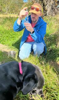


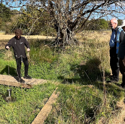
On 30 September we conducted a detailed water quality survey on the upper part of Redhill Brook catchment, visiting several sites where we tested water courses. Our group comprised River Mole River Watch, South East Rivers Trust and the Environment Agency and Simon Elson from Reigate Area Conservation Volunteers.
We chose Redhill Brook because it unfortunately ranks amongst the most polluted streams in the Mole catchment.
Redhill Brook has the 3rd highest long term average phosphate concentration and has consistently rated as Poor or Bad water quality every month over two years of WQ testing. Whilst Leigh Brook and Hookwood Common Brook rank worse in overall water quality, Redhill Brook is the largest stream with such poor water quality performance. At 40km² Redhill Brook is the largest tributary in the Mole catchment compared with Leigh Brook at 16km² and Hookwood at just 4km².


We were also keen to examine Redhill Brook more closely because it hosts such a wide range of landscapes and land uses, making it one of the most diverse catchments.
The upper catchment of Redhill Brook includes two busy motorways, the main London to Brighton railway, several lakes formed from restored quarries, four nature reserves, both active and restored sand quarries and landfills, and a large sewage treatment facility.
Thames Water completed upgrades to Merstham Sewage Works in March 2025, which heightened our interest in testing this catchment.
Several housing estates and residential areas, such as the Watercolour Development, are situated to the north of the wetland area in Merstham. The Moors nature reserve, a significant wetland with lakes, serves as natural flood management by retaining floodwater to help prevent flooding in Redhill. The images below show some of this diverse landscape.


Passing under the London to Brighton railway, the brook rapidly transitions into the highly urbanised and extensively culverted section through Redhill. It then passes through farmland before entering another culvert under Redhill aerodrome to join Salfords Streams.


During this visit, we concentrated testing on the upper course.
Catchment Background
Redhill Brook drains the eastern corner of the River Mole catchment. It is the largest tributary subcatchment in area covering 40km².

Redhill Brook follows an unusual course, originating from the scarp slope of the chalk Downs east of the M23. It flows southwest through the Vale of Holmesdale, then makes a sudden southward turn to pass between the greensand hills ridge between Redhill Common and Redstone Hill. Finally, it turns sharply east into the Low Weald before merging with Salfords Stream.

Geology and Relief


Redhill Brook is the largest of four neighbouring catchments in the Upper Mole that flow broadly south from the chalk scarp. This is contrary to the northerly drainage of the River Mole. Redhill Brook flows in an unusual curve related to how it crosses the major rock types and associated relief in the catchment: the chalk ridge, gault clay and lower greensand vale, the greensand ridge and the clay of the Low Weald.

Ephemeral springs in the chalk scarp of the North Downs provide modest seasonal flow for lakes and water courses on the gault clay before streams reach the lower greensand of the Vale of Holmesdale where groundwater further augments surface flow, originally creating marshes such as Nutfield Marsh. Resotration has formed a modern watery landscape by filling a series of old sand pits such as Mercers Lake and Spynes Mere.

The Vale of Holmesdale lies between the 200m ridge of the chalk North Downs and the 160m greensand ridge of Redhill Common and Nutfield. The greensand ridge is the same geological structure, albeit narrower and lower, as Surrey's Greensand Hills further west. The Greensand Ridge is largely absent in the Mole catchment, abruptly ending at Redlands Wood, Leith Hill and then only properly reemerging at Reigate Priory and Redhill Common before more steeply rising further east as a more substantial continuous ridge from Redstone Hill. The upper Redhill Brook catchment in the Vale of Holmesdale would thus be "enclosed" were it not for the Redhill Brook cutting an impressive "gorge" through the 150m greensand ridge: a narrow 75m deep valley between Redhill Common and Redstone Hill.


Land use: Quarries, Landfills and Nature Reserves
Quarries:
The geology of this catchment largely accounts for its hydrological features. Whilst Fullers Earth is believed to have been worked since Roman times, it is since the 1850s, that land east of Redhill has been most heavily quarried for industrial sands. Quarrying sandstone requires dewatering to prevent groundwater flooding in the pits. Although a few quarries remain operational, most have shut down, leading to a rise in groundwater levels as dewatering stops.
Some sand quarries, like the JJ Franks pit east of Mercers Park, are still active and dewater into Warners Brook, significantly increasing the flow in some streams.


Landfill:

With 100 years of quarrying in the area, numerous pits were available for landfill. However, the pits on the Marsh floor were left unfilled and allowed to flood to protect the greensand drinking water aquifer managed by SESW. It was the pits higher up on the greensand ridge that have been used as landfill sites for waste materials.
Landfilling at Patteson Court (now BIFFA) began in the mid-1980s for household, commercial and industrial waste. The landfill is constructed with an impermeable liner system to prevent leachate from seeping into the surrounding soil, groundwater or local water courses.

Wastewater and groundwater levels are managed through a comprehensive system involving collection, treatment, and monitoring, as mandated by environmental permits. Landfill leachate is directed to on-site treatment facilities and then either transported off-site or sent to the foul sewer for additional treatment at Merstham sewage works via the Holmethorpe pumping station. This process prevents landfill contaminants from polluting the surrounding environment through runoff or wastewater.
The BIFFA landfill site adheres to modern containment standards and monitors groundwater and surface water streams to ensure compliance.
However, older neighbouring landfills, such as the one east of Cormongers Lane, were constructed before stricter environmental regulations and do not meet the same tight containment standards of today. As a result, the ephemeral stream draining from the old Cormongers landfill has shown elevated contaminant levels in some tests conducted by BIFFA.
Rising groundwater across The Moors which is flooding some footpaths and leading to the diversion NC21 are regularly monitored by BIFFA.

More about water management at BIFFA: You may have noticed Warners Brook adjacent to the landfill has occasionally become discoloured with an ochre coloured deposit, especially collecting around vegetation. Whilst it looks grim, this is a harmless flocculant which was added to fix suspended material and address reactions from anaerobic to aerobic conditions in the settlement lagoons before finally discharging into Warners Brook. The flocculant deposition is now much reduced both because of reduced pumping and the building of further settlement lagoons to improve silt fixation before discharge. Leachate (runoff collected from the landfill) itself is collected in a piped system within the landfill, and pumped to the large white round tank at NW corner of site visible from the cycleway. Leachate is tankered off-site as and when needed, with a piped emergency link to Merstham sewage works, as an EA required failsafe. |
Restored landscapes:
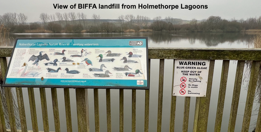
As quarrying and landfill operations ended phased opportunities arose to restore the landscape from abandoned sand pits. Projects included the creation of lakes and wetlands for recreation and wildlife, for example the Nutfield Marsh Project has created four wetland nature reserves, restored from sand workings: The Moors, Holmethorpe Lagoons, Mercer's West and Spynes Mere. Additionally, restoration created the water sports lake at Mercers Country Park. Redhill Brook flows through these restored landscapes.


Water Quality Test Results
Phosphate

Phosphate concentrations along Redhill Brook were exceptionally high, confirming that this stream remains one of the Mole’s most nutrient-enriched tributaries.

Upstream of the treated effluent outfall at Merstham Sewage Treatment Works (STW), phosphate measured 0.21 mg/L, on the boundary between Good and Moderate range of water quality. Immediately downstream of the treated effluent outfall, concentrations jumped to the top of our Hanna kit’s range (2.5 mg/L, classed Bad), indicating that treated effluent dominates the brook’s chemistry at low flows.
Downstream of the sewage works, three of the four test sites reached or exceeded the upper test limit, meaning true concentrations may be even higher.
Merstham sewage treatment works has a discharge permit limit for phosphorus P of 0.4 mg/l as a rolling 12 month mean. The limit for phosphate PO4 is 1.2 mg/l.
We measured >2.5mg/L phosphate PO4 downstream of Merstham sewage works which is more than twice the permitted level of phosphate.
The final test site downstream at Brambletye Bridge, our regular monthly test site, was still in the Poor water quality range.
This pattern strongly implicates Merstham STW treated effluent discharge as the main driver of phosphorus enrichment in Redhill Brook.

This is especially alarming because, during a recent Reigate and Banstead Borough Council Meeting, Thames Water stated that they finished upgrades to the Merstham works in March 2025.
These upgrades were intended to provide a higher quality of treated effluent going into the river, with a specific focus on reducing phosphate load, as highlighted in their presentation.
However, our test results indicate harmful levels of phosphate still present in the treated effluent discharged from the Merstham sewage works. This is evidence that the intended reduction in phosphate load has not been achieved, particularly under the vulnerable low flow conditions in which we conducted our tests. This suggests Thames Water may be choosing to cut operating costs by reducing the quantity of treatment chemicals (e.g. ferric chloride) supplied to the process. Alternatively the new equipment may not be functioning correctly. These are questions we will be asking Thames Water.

In contrast to Redhill Brook, Warners Brook, which currently receives relatively clean groundwater from dewatering upstream at the Franks Quarry, recorded much lower phosphate levels (0.20–0.29 mg/L, Good–Moderate).

The difference between these two streams—one fed by treated sewage, the other by groundwater—highlights how land use and water source directly shape river chemistry.
Nitrate
Nitrate results also showed consistently elevated levels in Redhill Brook, ranging from 0 mg/L upstream to 13–37 mg/L downstream, values typical of catchments dominated by wastewater and urban runoff.

Concentrations notably peaked around The Moors at 37.4 mg/L which suggests additional sources contributing to nitrate beyond sewage outfalls.

These results indicate both point-source inputs from the STW and diffuse sources from the surrounding urban and restored quarry landscapes.

By contrast, Warners Brook again performed well, with 0 mg/L nitrate at both sites—consistent with cleaner groundwater augmenting flow and limited contribution from any contaminated surface drainage.

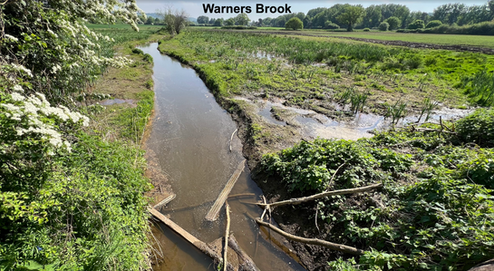
The image above illustrates the dual effects of dewatering activities. Warners Brook maintains a healthy flow due to active dewatering from the upstream Franks Quarry, even during a dry spell when nearby streams were low or dry. Additionally, the image highlights the consequences of decreased dewatering from closed quarries, as rising groundwater flooding is evident in the saturated adjacent fields.
Together, these data confirm that while groundwater-fed tributaries are relatively clean, Redhill Brook receives a strong nitrogen load downstream, driving the potential for algal growth and oxygen stress particularly during summer.
Ammonia
In these tests, ammonia provides the clearest signal of sewage impact.

The Environment Agency probe readings (converted to NH₃) show a sharp rise from 0.71 mg/L upstream (Moderate) to 2.50 mg/L downstream (Bad)—a level considered toxic to fish and invertebrates. Further downstream, concentrations remained Poor to Bad, with 1.83 mg/L at The Moors and 1.14 mg/L at Noke Drive. These results confirm that treated effluent still contributes substantial ammonia loads.

In contrast, Warners Brook ammonia readings (0.53–0.59 mg/L, Moderate) are within acceptable ecological limits and show the benefit of dilution by clean groundwater. The difference between the two brooks underlines how Redhill Brook’s quality is dictated by wastewater discharges rather than natural flow.
Conductivity


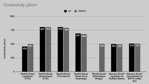
Conductivity readings further support this interpretation. At Redhill Brook, levels increased sharply from 501 µS/cm upstream to 810 µS/cm immediately below the STW, indicating a strong input of dissolved salts and ions from treated wastewater. Downstream, conductivity remained elevated (680–794 µS/cm) through to Noke Drive, suggesting that effluent continues to dominate the stream’s chemistry.

Warners Brook, by comparison, showed stable, low readings (496–510 µS/cm), typical of groundwater-fed streams. Conductivity therefore mirrors the nutrient and ammonia data, clearly marking the boundary where clean groundwater meets wastewater-enriched flow.
Dissolved Oxygen


Dissolved oxygen readings from the Environment Agency probe were reasonably good upstream (85% saturation) and increased to 95% just downstream of the STW outfall before declining further downstream.
The high DO% at the outfall is because of the mixing and turbulence of the water generated by the volume of discharge coming out of the STW into the brook, not because the water quality is good!
DO% is often higher downstream of large inputs of water like STW’s because of this mixing. Downstream readings for DO% are typically lower as turbulence reduces and microbial decomposition of effluent increases as displayed in our data shown by DO% declining to 65–77%. Although still within tolerable limits, these values indicate that oxygen stress could occur under warmer or lower-flow conditions, particularly during summer when biological oxygen demand increases.
Water Temperature


Water temperature also tracked the changing character of the brook, rising from 10.5°C upstream to 17–18°C downstream, consistent with effluent inputs from the STW, which typically release warmer water than the ambient stream temperature. Elevated temperature reduces oxygen solubility, reinforcing the mild oxygen depletion observed downstream.
In contrast, Warners Brook maintained somewhat cooler, steady temperatures (14–16°C), consistent with groundwater inflow.
Summary and interpretation
Our survey of Redhill Brook paints a clear picture of a catchment still dominated by wastewater influence despite claims of recent improvement. All our tests —phosphate, nitrate, ammonia, conductivity, and temperature—show a marked deterioration in water quality downstream of Merstham Sewage Treatment Works, while dissolved oxygen declines accordingly.
This is especially significant given that Thames Water completed its upgrade to the Merstham STW in March 2025, which was intended to reduce phosphate and improve effluent quality. The fact that our September tests found phosphate levels more than twice the permitted discharge limit and ammonia levels classed as Poor to Bad strongly suggests that these upgrades have not yet delivered measurable improvements in river water quality.
In contrast, the effects of rising groundwater markedly improve water quality in some streams. For example, Warners Brook shows how clean groundwater input can improve sustained baseflow and maintain moderate to good conditions. It is important to note that our tests identified no impact on water quality from landfill discharges. However, on this occasion, the outfall from the BIFFA site into Warners Brook was not discharging so we plan to return at a time when it is active.

The combination of elevated nutrients, high conductivity, warmer water, and reduced oxygen downstream of the STW indicates a system under stress, where treated effluent still forms a major proportion of flow during dry periods.
Until the upgraded treatment process delivers genuine reductions in pollutant loads, the ecological condition of Redhill Brook is unlikely to improve.
While additional flow from groundwater probably dilutes the impact from the Thames Water Merstham outfall, there are very likely to be other pollution sources contributing to the ongoing poor water quality downstream. For example, domestic misconnections, industries and consented discharges as well as lengthy culverted sections likely contribute to the poor quality of Redhill Brook as far downstream as our monthly test site at Brambletye Bridge in Earlswood. Furture testing will hopefully identify other sources.


Our test findings underline the importance of maintaining strong treatment performance and pursuing opportunities for phosphate and ammonia reduction at sewage treatment works. At the same time, the benefits observed in Warners Brook show how groundwater recharge and good management of quarry and landfill operations can help sustain better river health.


This collaborative survey provides a clear, evidence-based understanding of local pressures for further discussions with Thames Water, BIFFA, and environmental regulators on how to manage pollutant loads entering the Redhill Brook.


Closing remarks
This survey demonstrates the vital importance of independent monitoring to verify whether investment in sewage infrastructure actually results in cleaner rivers. Despite recent upgrades at Merstham STW, our results reveal continuing high phosphate and ammonia levels that fall short of expectations for improved effluent quality.
By combining citizen science sampling with Environment Agency and South East Rivers Trust expertise and local knowledge of quarrying and land restoration from Simon Elson, we have built a clearer picture of the pressures affecting Redhill Brook catchment—and the evidence to question whether regulatory targets and upgrades translate into real-world improvements.
Continued partnership between community groups, regulators, and water companies will be essential to track progress, ensure transparency, and deliver tangible water quality gains in the Redhill Brook catchment.
Thank you for reading. Please Like, Share and Comment to support our call for data-driven accountability and cleaner rivers.


Comments